


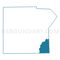
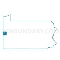
PERRY TWP VTD 02, Lawrence County, Pennsylvania
About
Outline

Summary
| Unique Area Identifier | 660525 |
| Name | PERRY TWP VTD 02 |
| County | Lawrence County |
| State | Pennsylvania |
| Area (square miles) | 17.88 |
| Land Area (square miles) | 17.73 |
| Water Area (square miles) | 0.15 |
| % of Land Area | 99.15 |
| % of Water Area | 0.85 |
| Latitude of the Internal Point | 40.88564100 |
| Longtitude of the Internal Point | -80.19046630 |
Maps

Graphs
Select a template below for downloading or customizing gragh for PERRY TWP VTD 02, Lawrence County, Pennsylvania


Neighbors
Neighoring Voting District (by Name) Neighboring Voting District on the Map
- FRANKLIN TWP VTD EAST, Beaver County, PA
- FRANKLIN TWP VTD WEST, Beaver County, PA
- LANCASTER TWP Voting District, Butler County, PA
- MUDDYCREEK TWP Voting District, Butler County, PA
- PERRY TWP VTD 01, Lawrence County, PA
- SLIPPERY ROCK TWP VTD 01, Lawrence County, PA
- SLIPPERY ROCK TWP VTD 02, Lawrence County, PA
- SLIPPERY ROCK TWP VTD 03, Lawrence County, PA
- WAYNE TWP VTD 02, Lawrence County, PA
Top 10 Neighboring County Subdivision (by Population) Neighboring County Subdivision on the Map
- Franklin township, Beaver County, PA (4,052)
- Slippery Rock township, Lawrence County, PA (3,283)
- Wayne township, Lawrence County, PA (2,606)
- Lancaster township, Butler County, PA (2,532)
- Muddy Creek township, Butler County, PA (2,254)
- Perry township, Lawrence County, PA (1,938)
Top 10 Neighboring Unified School District (by Population) Neighboring Unified School District on the Map
- Seneca Valley School District, PA (46,966)
- Slippery Rock Area School District, PA (20,583)
- Ellwood City Area School District, PA (14,362)
- Riverside Beaver County School District, PA (10,453)
- Laurel School District, PA (8,107)
Top 10 Neighboring State Legislative District Lower Chamber (by Population) Neighboring State Legislative District Lower Chamber on the Map
Top 10 Neighboring State Legislative District Upper Chamber (by Population) Neighboring State Legislative District Upper Chamber on the Map
- State Senate District 50, PA (235,966)
- State Senate District 21, PA (235,571)
- State Senate District 47, PA (225,797)
Top 10 Neighboring 111th Congressional District (by Population) Neighboring 111th Congressional District on the Map
Top 10 Neighboring Census Tract (by Population) Neighboring Census Tract on the Map
- Census Tract 9110, Butler County, PA (6,278)
- Census Tract 9118, Butler County, PA (6,189)
- Census Tract 6051, Beaver County, PA (4,965)
- Census Tract 115, Lawrence County, PA (4,176)
- Census Tract 109, Lawrence County, PA (3,283)